The Wertsner Mill
- Yen Ho
- Jul 24, 2021
- 3 min read
Updated: Sep 16, 2021
The Wertsner Mill was one of the mills that was part of the early history of Ambler, even though this mill was located in the Whitpain Township. Before it was owned by Adam Wertsner, it was owned by James Morris who also owned the Dawesfield homestead where General George Washington used as his headquarters during the American Revolution.
The James Morris Mill
It started with James Morris's father Joseph Morris who owned this land until he died, and James inherited the land ever since.
James was interested in agricultural pursuits, and not the grist mill business. But, it wasn't until Washington and his officers settled in his Dawesfield home during the Philadelphia Campaign.
"Brigadier-General Weeden's regiment of Virginia troops was encamped on James Morris' farm from October 19 to November 2, 1777. During their stay the season was very rainy and they met with many discomforts, due to the weather condition. This fact and many other greater discomforts which were possible in the coming winter season, were grave dangers to be met. In this emergency, they lost no time in preparing a way to meet them. They saw the necessity for places of shelter. To provide these, they felled the timber in the surrounding forest and began to erect structures which would give them a more favorable out-look of comfortable living, and relieve their minds of future dangers of sickness due to the exposure to the elements."
- Hough, Early History of Ambler
After the troops left his home, leaving behind fallen timber from the surrounding forest, James saw the opportunity to build his gristmill. Another benefit for James to build his gristmill was the Prophecy Creek that flows through the land.
The Wertsner Mill
After James Morris died in 1796, his wife Elizabeth and his daughter Hannah sold his gristmill and land to Adam G. Wertsner (1756-1831) for 1,000 pounds sterling (1,389.23 USD).
In 1856, the Great Train Wreck occurred between Camp Hill and Fort Washington stations where two trains collided into each other, killing 59-67 people on board. Adam's gristmill was one of the hot spots during that time due to a runaway engineer responsible for the train wreck.
"In July of that year, a railroad accident occurred near Fort Washington which resulted in the death of several persons. The arrest and conviction of the engineer of the train was demanded by members of some of the surviving families, who thought that as the cause of the accident, he should receive the punishment due him. It was learned that he was secreted in the Wertsner Mill. He escaped however, and the large number of people who had congregated there in the hopes of securing his arrest were much disappointed in their failure to apprehend him. He later committed suicide at his home in Philadelphia. Mrs. Eugene Nice, a daughter of Adam Wertsner, frequently related this event which occurred at her home in her childhood."
- Hough, Early History of Ambler
During Adam's ownership of the gristmill, he added a cider mill.
After Adam died in 1831, his son George took over the mill while his mother took part of the property on the north side that was added in 1820. After George died in 1876, Adam's other son Albert purchased the property and added additional 12 acres from the original tract.
After Albert, there were a variety of owners who lived on the former Wertsner property:
May 3, 1878- Albert's widow Hannah Kiesel Wertsner
May 16, 1878- Ann Jane Mercer
1886- S. Wilson Fisher
1909- Elizabeth Fisher
1916- Clarence W. Fisher (S. Wilson Fisher's son)
1933- Bertha Jenks
1935- Charles and Rita Platt (restored and improved the house)
1946- Antelo and Sydney C. Devereux
NOTE: According to the PA Historic Resource Survey Form, there was a Victorian Gothic home on the property, even though the form also said that it was a colonial home. Unfortunately, there were no pictures to show its architectural features, so I couldn't come up with any conclusions on this. Even looking at Google Maps didn't give me a good quality since the land was surrounded by thick trees. The survey form said that the building was in excellent condition, but did not have the potential of being nominated to the National Register of Historic Places. It's still unclear to come up with any conclusions.
The mill ceased operation in 1887.
Fun Fact: A photograph of the mill was done by a local artist, requested by Adam's daughter Eugene Nice. It is currently in possession of her descendants.


Bibliography
"Google Maps Area Calculator Tool." DaftLogic. Accessed March 16, 2021. https://www.daftlogic.com/projects-google-maps-area-calculator-tool.htm.
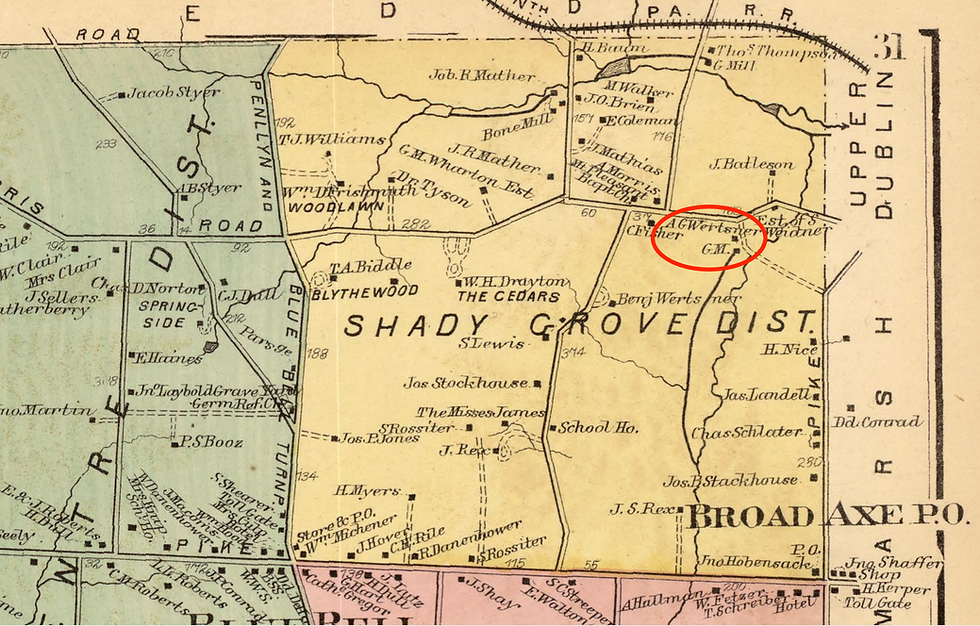
Hopkins, G.M. Atlas of Montgomery County, Pennsylvania, Page 031, 1871.
Hough, Mary P. H. "Early history of Ambler 1682-1888.” A Celebration of Women Writers. Accessed March 16, 2021. https://digital.library.upenn.edu/women/hough/ambler/ambler.html.
Mueller, A. H. Atlas of the North Penn Section of Montgomery County, Pa., Plate 28, 1916.
Whitpain... Crossroads in Time. (Montgomery County, PA: Whitpain Township Bicentennial Commission, 1977): 334-339.


Comments